| Author |
 Topic Topic  |
|
ToninoTarsi
Falchetto

Italy
113 Posts |
 Posted - 25/02/2017 : 10:12:15 Posted - 25/02/2017 : 10:12:15


|
It is available for download a new version of LKMAPS Desktop that can produce both terrain and topology for LK8000. Download for a beta version is here :
https://tinyurl.com/z7sontm
The main source of maps, for LK8000, always remains the pre-elaborated one that can be downloaded from http://www.lk8000.it/download/maps.html , but, if your area is not covered or you want a more up to dated map, you can try this tool.
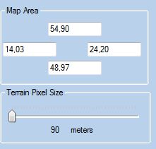
Terrain is from 90 meters resolution NASA SRTM data. If you area is very big you can think reducing this resolution. Anyway if you are running on Android or Koko you can also produce a very large 90 meters terrain and will work fine.
For topology the software uses OpenStreetMap querying the database using Overpass API. Here, if your area is big, it can require time to get the desired data. Be patient and let it work. There is 1 hour timeout on the server so if you do not get data alter this time you can close and retry later when the server is less busy. Anyway downloading the demo area only require 3-5 minutes.
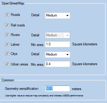
If your area is big also consider to simplify your geometry increasing the "Geometry simplification" parameter you have in the option dialog . Increasing this parameter will increase LK8000 drawing performance. Even if you use 150 or 200 meters you will not notice the quality difference during flight. The option menu also gives you some control on what you really want on the map. ( see image below)

Report any issue here
Tony
|
www.VoloLiberoMonteCucco.it |
Edited by - ToninoTarsi on 25/02/2017 10:15:50 |
|
|
Coolwind
Moderator

Italy
8957 Posts |
Posted - 25/02/2017 : 14:10:02

|
| great tool thanks Tony! |
 |
|
|
ryszard_lewandowski
Pulcino

Poland
51 Posts |
Posted - 03/03/2017 : 09:32:14
|
Tony, excellent work!
I'm trying produce a new map for Poland with Medium details (Roads,Citys). Yes, I know it's quite huge area. The terrain works fine but I can't produce the topology. The program worked even 7-8 hours and didn't finish work (the progress bar still moving). Is it possibly that it can take more than 8 hours? I have excellent internet link (>80Mb/s). |
http://lotynamotolotni.pl |
|
|
|
ToninoTarsi
Falchetto
Italy
113 Posts |
Posted - 03/03/2017 : 18:57:31
|
Hi,
could you please provide the coordinates of the bounding box you are trying to get ?
Thanks
Tony
|
www.VoloLiberoMonteCucco.it |
|
|
|
ryszard_lewandowski
Pulcino
Poland
51 Posts |
|
|
ToninoTarsi
Falchetto
Italy
113 Posts |
|
|
ryszard_lewandowski
Pulcino
Poland
51 Posts |
|
|
ryszard_lewandowski
Pulcino
Poland
51 Posts |
Posted - 04/03/2017 : 00:12:58
|
Tony, a few more things.
All examples for the coordinates: 19,70..22,02 and 52,11..53,11.
- Options->Roads: ComboBox has "VeyHigh" instead of "Very High".
- Generally with VeryHigh (in both checkboxes: Road and Citys {rather cities} ) options is something wrong. LKM file with Citys->VeryHigh is smaller than file with Citys-High (eg. Citys-VeryHigh=304kB versus Citys-High=407kB). LKM file with Roads->VeyHight is extremely smaller than file with Roads->High (eg. Roads-VeyHigh=13kB versus Roads-High=304kB).
- In Polish language we have diacritics signs. For example we have city
 . In POL.LKM (old file) everything is OK ( is presented as Pultusk). In new files - generated from LKMAPS is presented as Pu?tusk. . In POL.LKM (old file) everything is OK ( is presented as Pultusk). In new files - generated from LKMAPS is presented as Pu?tusk.
- In old POL.LKM file middle and large cities are presented by yellow polygons. It's very useful. The files generated from LKMAPS present the cities only as points.
Sorry for the big images but forum converts diacritics.
I would like to update old POL.LKM. Do you think that merge new road*_line.* files into old POL.LKM file is a good idea? |
http://lotynamotolotni.pl |
Edited by - ryszard_lewandowski on 04/03/2017 00:21:56 |
|
|
|
ToninoTarsi
Falchetto
Italy
113 Posts |
Posted - 04/03/2017 : 16:37:09
|
quote:
I would like to update old POL.LKM. Do you think that merge new road*_line.* files into old POL.LKM file is a good idea?
Yes. If you really need that big area you can download data from : http://download.geofabrik.de/europe/poland.html
and then replace single shapefile. But this will require some GIS knowledge and a GIS software ( like open source QGIS )
Tony
|
www.VoloLiberoMonteCucco.it |
|
|
|
ryszard_lewandowski
Pulcino
Poland
51 Posts |
Posted - 05/03/2017 : 09:03:36
|
| Thanks for the tip. I have installed QGIS - great tool. I will try to produce up-to-date layers. |
http://lotynamotolotni.pl |
|
|
|
ToninoTarsi
Falchetto
Italy
113 Posts |
Posted - 05/03/2017 : 22:17:52
|
There is a new version available that is in beta-beta-beta state but you can try it. To update just start the application that will ask for update.
News :
Beside the online topology ( that direly query the OSM server ) there is an offline version. For this version you should first download an OpenStreetMap file ( binary .pbf preferable but also work with ascii .osm ) and then use that file for processing.
Clicking on the "Offline Topology" button you will be redirect to a download page to get the file for your area. Try to download the smaller possible file as this will faster the process.
Just an Idea to overcome OSM server limitations.
Tony
|
www.VoloLiberoMonteCucco.it |
Edited by - ToninoTarsi on 05/03/2017 22:18:52 |
|
|
|
ryszard_lewandowski
Pulcino
Poland
51 Posts |
Posted - 06/03/2017 : 10:58:55
|
Thanks I will try.
By the way - Now I know what did you mean when you said "This is a really really really really big area". With QGIS and local data I made city_area layer by converting buildings layer with "fix distance buffer" and aggregation. Just for one district (1/16 of whole Poland - 600k+ buildings) it takes 29 hours :) |
http://lotynamotolotni.pl |
|
|
|
ToninoTarsi
Falchetto
Italy
113 Posts |
Posted - 06/03/2017 : 11:37:54
|
With the new offine mode I just processed all Poland in about 10 minutes.
Result here : http://www.vololiberomontecucco.it/temp/Poland.LKM
Known left issues :
1) Unicode strings in city names
2) Level of details not working perfectly
Both will be fixed this evening with new version
Tony
|
www.VoloLiberoMonteCucco.it |
Edited by - ToninoTarsi on 06/03/2017 11:38:32 |
|
|
|
mzeddd
Pulcino
Russia
82 Posts |
|
|
ToninoTarsi
Falchetto
Italy
113 Posts |
Posted - 06/03/2017 : 21:27:53
|
No there should be no difference from where you download a pbf file provided the file is correct. As first test please download from the link provided.
The new version with the 2 fixes is available
Tony
|
www.VoloLiberoMonteCucco.it |
|
|
|
ryszard_lewandowski
Pulcino
Poland
51 Posts |
Posted - 07/03/2017 : 00:06:06
|
Tony, the new version works very fast. How do you produce city area? There are a lot of places where you can find a lot of buildings but city area shows just small part.
Take a look at the images.
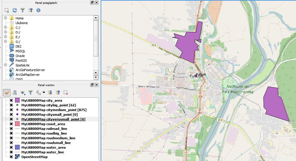
Layers: citysmall, cityverysmall are empty (Cities: Medium). I will try with "High" and "VeryHigh" details for Cities. |
http://lotynamotolotni.pl |
|
|
|
Topic |
|